【WPMの測定手順】
読む前に設問を確認する
時計(ストップウォッチ)を見ながら、英文を最初から最後まで読み、かかった秒数を記録する
設問に解答する
答え合わせをして正解数を確認する
以下の計算式でWPMを算出する
WPM = 語数 ÷ 読むのにかかった秒数 × 60 × 正解数 ÷ 設問数
※読んだ内容の理解を測定せずただ英文を読むスピードをチェックしたい場合は、WPM = 語数 ÷ 読むのにかかった秒数 × 60 まででOK。
Africa on the World Map: A New Perspective
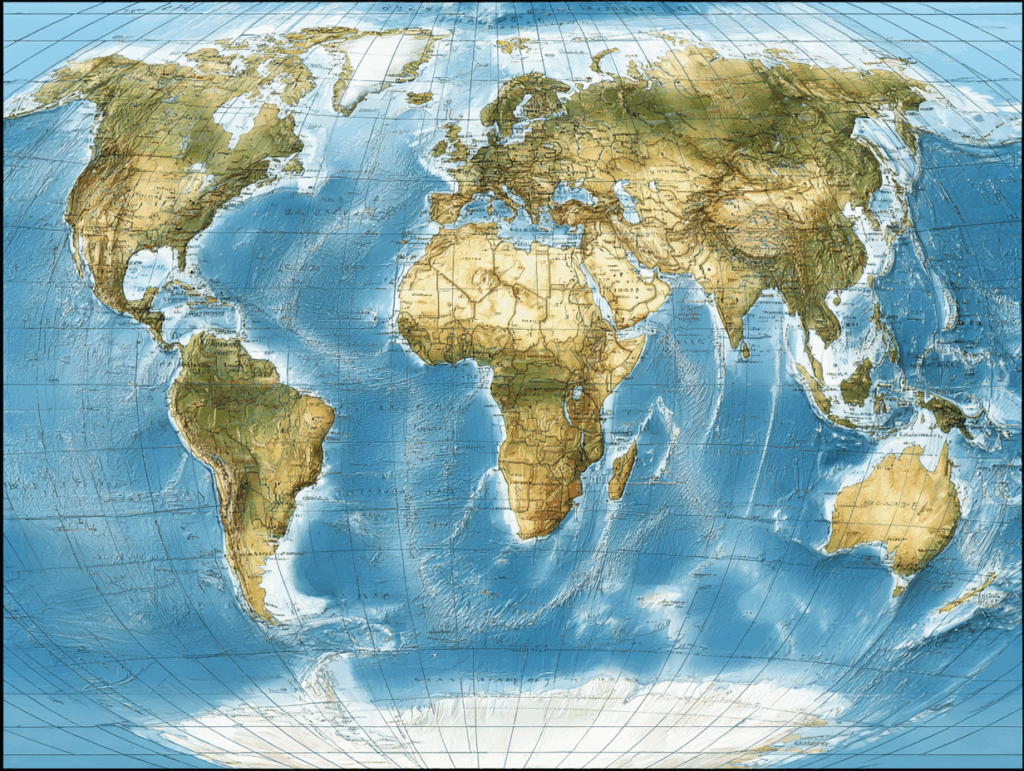
Africa is the second largest continent in the world, but many people do not realize how big it really is. This is because most world maps today are based on the Mercator projection. The Mercator map was created in the 16th century to help sailors travel across the oceans. It is very good for showing directions, but it distorts the size of countries and continents.
On the Mercator map, Africa looks smaller than it really is. For example, Greenland appears almost as big as Africa, but in reality Africa is about 14 times larger. Europe and North America also look bigger than they are, while Africa and South America look smaller. This creates a false idea about the importance of different regions.
Because of this, the African Union has started a campaign called “Correct the Map.” They want schools and governments to use more accurate world maps. One alternative is the Equal Earth projection, which shows continents in their true size while keeping a simple, familiar shape. Supporters say this change will help students and people everywhere understand the world more fairly.
Changing maps may seem small, but it can change the way people see the world. When Africa is shown at its real size, people may better appreciate its land, resources, and population. A fair map can help create a fairer view of our planet. (234 words)
☆Answer the questions☆ (2×4=8)
(1) What is the main problem with the Mercator projection?
a) It is too old
b) It shows wrong directions
c) It distorts the size of countries
d) It is difficult to read
(2) How many times larger is Africa than Greenland?
a) 4 times
b) 10 times
c) 14 times
d) 20 times
(3) What is the name of the campaign started by the African Union?
a) Save the Map
b) Correct the Map
c) Equal Earth
d) Fair World
(4) What does the Equal Earth projection try to do?
a) Show directions for sailors
b) Make the map smaller
c) Show continents in their true size
d) Remove Africa from the map
【Answer】
(1) c) It distorts the size of countries
解説:メルカトル図法は国や大陸の大きさをゆがめて表示します。
(2) c) 14 times
解説:本文に「Africa is about 14 times larger」とあります。
(3) b) Correct the Map
解説:アフリカ連合が始めたキャンペーンの名前です。
(4) c) Show continents in their true size
解説:Equal Earth図法は大陸を本来の大きさで見せることを目的としています。
【入試超絶頻出単語】
□ projection(投影法・図法)
□ distort(歪める)
□ continent(大陸)
□ campaign(運動)
□ accurate(正確な)
□ alternative(代替案)
□ appreciate(正しく理解する)
□ population(人口)
□ resources(資源)
【全訳】
アフリカは世界で2番目に大きな大陸ですが、その大きさを正しく知っている人は多くありません。その理由は、現在広く使われている世界地図の多くが「メルカトル図法」に基づいているからです。メルカトル図法は16世紀に航海用として作られ、方向を示すのに便利ですが、国や大陸の大きさを歪めてしまいます。
メルカトル地図では、アフリカは実際より小さく見えます。例えば、グリーンランドはほぼアフリカと同じ大きさに見えますが、実際にはアフリカは約14倍も大きいのです。ヨーロッパや北アメリカは実際より大きく、アフリカや南アメリカは小さく見えてしまいます。これにより、地域の重要性について誤った印象が生まれます。
このため、アフリカ連合は「Correct the Map」というキャンペーンを始めました。学校や政府がより正確な地図を使うことを求めているのです。その代替案のひとつが「Equal Earth図法」で、大陸の本当の大きさを保ちながら、わかりやすい形を維持しています。支持者たちは、この変更が人々により公平な世界観を与えると考えています。
地図を変えることは小さなことのようですが、人々の世界の見方を変える可能性があります。アフリカが本当の大きさで描かれれば、その土地・資源・人口をより正しく理解できるでしょう。公平な地図は、公平な地球観をつくる助けになるのです。